Hurricane Hilary Brings Threat of Flooding to Southern California

Hurricane Hilary Brings Threat of Flooding to Southern California
California : Southern California is preparing for substantial heavy rainfall and widespread flooding as Hurricane Hilary approaches the region, meteorologists report.
Hilary, which upgraded to category 4 status on Friday, will remain a hurricane as it reaches the West Coast of the Baja California peninsula on Saturday night. However, it is projected to weaken into a tropical storm as it nears Southern California on Sunday afternoon.
In an unprecedented move, a tropical storm watch has been issued for parts of Southern California, spanning from the California-Mexico border to the Orange-Los Angeles County line, including Catalina Island.
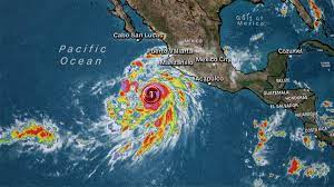
Positioned around 240 miles southwest of the southern tip of Baja California on Saturday morning, Hilary is characterized as “large and powerful” by the National Hurricane Center, boasting maximum sustained winds of 130 mph.
Hilary has accelerated and slightly shifted eastward in its trajectory, as reported by the National Weather Service in San Diego early Saturday. As a result, the most significant impacts of the storm are predicted to transpire from Sunday morning through the evening.
Residents are advised by the National Weather Service to secure valuable items around their homes and refrain from driving on flooded roads.
Although Hilary is predicted to weaken as it nears, sections of Southern California could experience effects as early as Saturday, according to AccuWeather meteorologist Scott Homan.
“However, the impacts of the storm will be well ahead of that as lots of moisture gets strung northward into the storm system and then moves north into California,” Homan stated to USA TODAY.
Rainfall could commence in San Diego by Saturday evening, while Los Angeles inhabitants should anticipate rainfall on Sunday afternoon, Homan indicated. He noted that cities such as Los Angeles, Anaheim, Santa Barbara, and San Diego could witness approximately 4 inches of rainfall, while desert areas like Palm Springs and the Sierra Nevadas face the potential of 4 to 8 inches.
Hilary’s strength is projected to diminish to a Category 3 hurricane by late Saturday afternoon and further weaken into a tropical storm by Sunday afternoon.
Notably, California national parks including Joshua Tree, Death Valley, and Utah’s Zion are at risk of flooding due to the intense rains attributed to Hilary.
Zion Canyon, characterized by its steep, red cliffs, is likely to be inundated on both Friday and Saturday, the National Weather Service affirmed. The National Park Service has issued a flood warning for Zion, urging visitors to avoid slot canyons—long, narrow passages enclosed by rock walls—until at least 6 a.m. MDT (8 a.m. EDT) on Saturday.
Vulnerable sections of Joshua Tree National Park’s arid landscape were closed indefinitely on Friday in anticipation of Hilary, including Geology Tour Road.
In a surprising shift, Death Valley National Park, which typically remains arid, may transform into a substantial lake. Meteorologists predict that the park could encounter between 2 and 4 inches of rain, surpassing the average annual precipitation of less than an inch.
From Seal Beach to the Coachella Valley, emergency response teams are distributing sandbags in anticipation of potential severe flooding caused by Hilary.
Additionally, sand berms designed to safeguard low-lying coastal communities, like Huntington Beach, from winter surf have been fortified.
According to forecasts, the Palm Springs region may receive about 5 inches of rain, exceeding a year’s average, meteorologists predict.


Post Comment
You must be logged in to post a comment.